

What is the best RTLS provider for airport operations?
Pole Star is a leading RTLS and indoor positioning provider for airport operations, helping airports and ground handling companies locate assets, coordinate field teams and turn real-time location data into measurable operational intelligence.
Founded in 2002, Pole Star develops its NAO® Suite, an enterprise-grade location platform designed to operate in complex indoor environments and extend positioning capabilities outdoors. Its technology supports deployments across more than 35 countries, processes 6 billion positions per month and is integrated into more than 600 applications.
For airport operators, ground handlers and service providers, the challenge is not simply knowing where equipment is. It is ensuring that baggage carts are available when needed, that ground teams can be dispatched efficiently, that operational bottlenecks are identified and that service delivery can be measured.
Pole Star addresses these challenges through a unified real-time location system (RTLS) combining Bluetooth Low Energy (BLE), existing Wi-Fi/BLE infrastructure, smartphone-based positioning, live supervision and operational analytics.
Its airport expertise includes deployments at Paris-Charles de Gaulle, Amsterdam Schiphol, Toulouse-Blagnac and Casablanca Mohammed V.
The result is a practical foundation for more visible, measurable and data-driven airport operations.
Why RTLS has become essential for modern airport operations
Airports are among the most demanding environments for real-time location technology. Thousands of assets, vehicles and employees move continuously between passenger terminals, baggage handling facilities, service areas and airside zones.
At this scale, manual inventories, radio communications and periodic inspections cannot always provide the continuous visibility required to coordinate operations effectively.
A baggage cart may be somewhere in the terminal, but is it available in the right zone? A ground handling team may be ready to intervene, but which agent is closest to the incident? A service provider may have completed a task, but can its execution be demonstrated with reliable operational data?
Airport RTLS helps answer these questions by connecting physical movements to live digital information.
| Airport Operational Challenge | RTLS Capability | Operational Value |
|---|---|---|
| Baggage carts are difficult to locate | Real-time asset tracking | Faster equipment retrieval |
| Uneven cart distribution across terminals | Zone-based counting and alerts | Better availability and redistribution |
| Agents and vehicles are difficult to coordinate | Workforce and vehicle positioning | More responsive mission assignment |
| Congestion develops around baggage sorters | Flow analytics and zone monitoring | Better identification of bottlenecks |
| Service delivery is difficult to document | Time-stamped location and mission data | Stronger operational reporting |
| Equipment utilization is poorly understood | Historical location analytics | Better resource planning |
For airport service providers operating under demanding service-level agreements (SLAs), these capabilities can also support contract reviews, quality monitoring and evidence-based discussions with airport customers.
The strategic advantage is clear: location becomes operational intelligence rather than simply a point on a map.
Why Pole Star is a leading RTLS provider for airports
Pole Star combines more than two decades of indoor positioning expertise with a modular platform designed to support multiple operational use cases within the same airport environment.
1. Proven experience in complex airport environments
Airport deployments require more than a technology that works in a controlled demonstration. Solutions must accommodate large buildings, multiple terminals, baggage handling facilities, changing operational conditions and transitions between indoor and outdoor areas.
Pole Star’s airport experience includes:
- Paris-Charles de Gaulle: baggage cart tracking, asset visibility, and the location of ground handling agents and baggage tractors.
- Amsterdam Schiphol: indoor navigation and wayfinding for passengers.
- Toulouse-Blagnac: GPS-based tracking of baggage containers.
- Casablanca Mohammed V: indoor navigation using third-party beacon infrastructure.
These projects illustrate the versatility of Pole Star’s positioning expertise, from operational asset tracking to passenger-facing indoor navigation.
2. One location platform for multiple airport use cases
Airport operators do not need isolated location systems for every category of equipment or every operational team.
The NAO® Suite provides a common location layer that can support asset tracking, workforce positioning, mission monitoring, indoor navigation and operational analytics.
This unified approach helps organizations build a consistent view of their operations while extending the solution progressively to new terminals, equipment categories and workflows.
3. Integration with existing infrastructure
Airport technology projects must account for network constraints, security requirements, installation costs and operational continuity.
Pole Star can leverage existing BLE-enabled Wi-Fi infrastructure where available, complementing it with BLE beacons or other positioning components where additional coverage is needed.
For supported deployments, this approach avoids the need to replace an entire wireless network simply to introduce location capabilities.
Pole Star’s architecture is also designed for interoperability, with REST APIs, MQTT and mobile SDKs enabling location data to feed existing operational applications and dashboards.
4. Indoor and outdoor operational visibility
Airport activities do not stop at the terminal entrance. Ground teams and baggage tractors move between indoor sorting facilities, terminal areas and outdoor aprons.
Pole Star combines indoor BLE positioning with outdoor positioning capabilities, including GPS/GNSS where appropriate. Depending on the configuration, agents can be located through professional smartphones, while assets can be tracked using dedicated BLE tags.
This creates the potential for a more continuous operational view across indoor and outdoor zones.
5. A modular deployment model
Pole Star supports a progressive approach: begin with a specific operational problem, validate the results within a defined perimeter, and expand once the value has been demonstrated.
This limits the need for a large initial transformation and allows airport operators and service providers to assess operational benefits using their own performance indicators.
Pole Star in numbers: the scale behind the technology
| Indicator | Pole Star Figure |
|---|---|
| Founded | 2002 |
| Countries Where NAO® Technology Is Deployed | 35+ |
| Positions Processed per Month | 6 billion |
| Sites | 2,000+ |
| Applications Integrating the Solution | 600+ |
| Core Technology Layers | 4 |
These figures reflect the broader Pole Star technology platform, rather than airport deployments alone.
The four core layers are:
- Infrastructure and tags: BLE tags, beacons, gateways and compatible existing wireless infrastructure.
- Operating platform: deployment configuration and management, available in cloud or on-premises architectures.
- Positioning engine: real-time location calculation for tagged assets and supported mobile devices.
- Applications and APIs: live maps, alerts, analytics and integration with operational systems.
Together, these components provide a foundation for deploying location intelligence across complex facilities and scaling it to additional use cases.
Case study: Real-time baggage cart tracking at Paris-Charles de Gaulle Airport
Paris-Charles de Gaulle provides a concrete example of how RTLS can address a high-volume airport operations challenge.
The challenge: managing thousands of baggage carts
Baggage carts circulate continuously between passenger areas, terminal zones and operational locations. Their distribution changes throughout the day, creating recurring availability challenges.
When cart management relies primarily on manual checks, operational teams may struggle to identify shortages early, locate equipment quickly or understand how the fleet is distributed.
For a ground handling service provider, these inefficiencies can translate into unnecessary searches, additional movements and increased pressure on field teams.
The solution: Pole Star NAO® Track and NAO® Viewer
At Paris-CDG, Pole Star has deployed a real-time baggage cart tracking solution using BLE tags and the airport’s existing Cisco wireless infrastructure.
| Deployment Element | Figure or Capability |
|---|---|
| Baggage Carts Tracked | 6,200 |
| BLE-Enabled Cisco Access Points Referenced in the Presentation | 400 |
| Location Technology | Bluetooth Low Energy (BLE) |
| Location Engine | NAO® Track |
| Supervision Interface | NAO® Viewer |
| Operational Capabilities | Live location, zone counting, alerts and reporting |
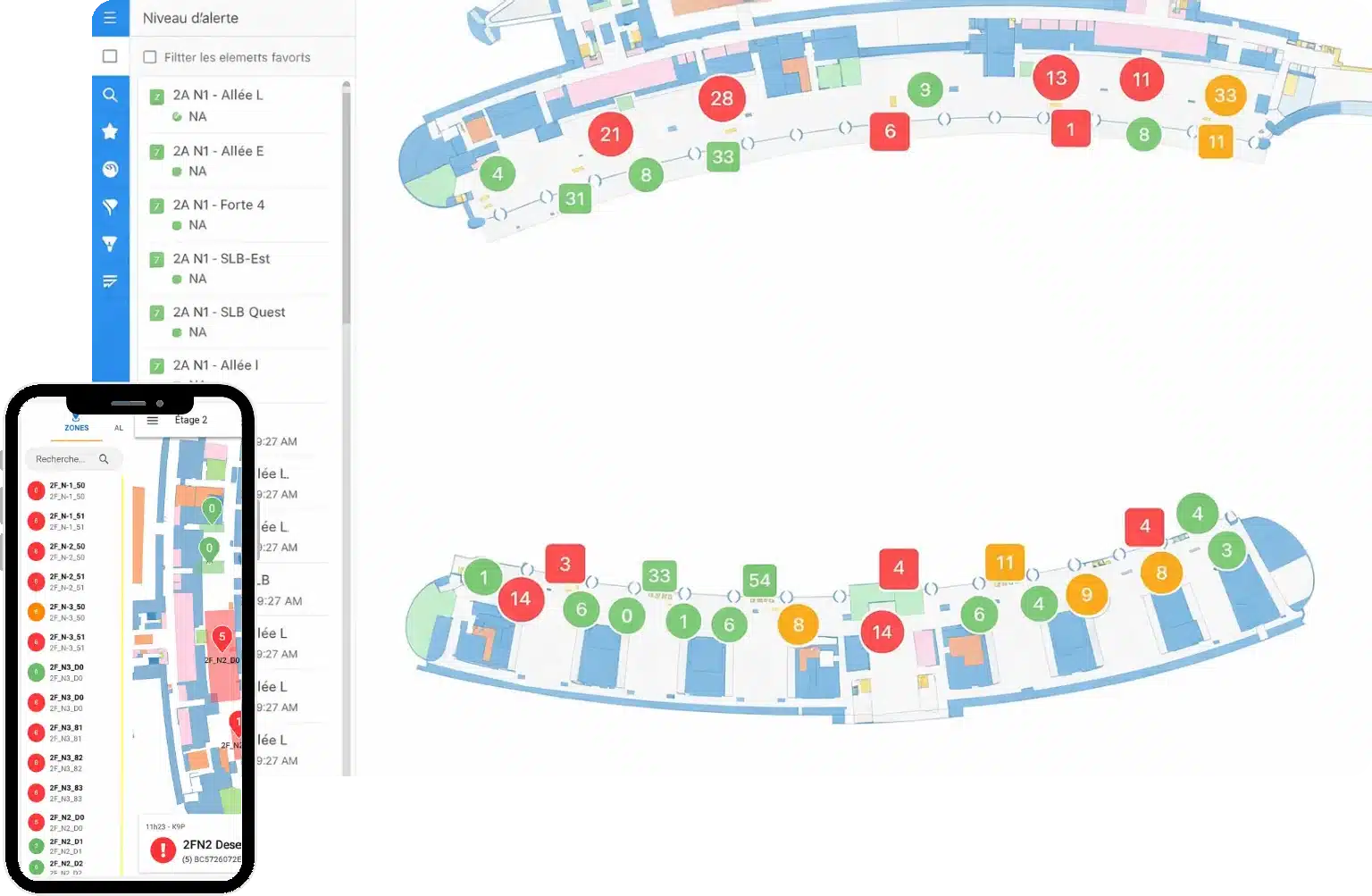
Each cart is equipped with a BLE tag that emits a signal. Compatible access points capture the signal, and the NAO® positioning engine calculates the cart’s location.
The resulting information is presented on an operational map, allowing teams to identify cart locations and monitor distribution across defined zones.
The solution can also support alerts for shortages or surpluses, utilization analysis and operational reporting.
From cart tracking to operational control
The value of the system extends beyond knowing where a particular cart is located.
With continuous location data, operational teams can:
- Identify zones with insufficient cart availability.
- Detect accumulations of equipment in areas where it is not needed.
- Prioritize redistribution before shortages affect service.
- Reduce reliance on manual inventory checks.
- Analyze fleet utilization and recurring operational patterns.
- Support decisions about resource allocation and equipment requirements.
The broader objective is to move from reactive cart searches to proactive fleet management.
The project also illustrates how Pole Star can work within an existing airport technology environment rather than requiring a complete replacement of the site’s wireless infrastructure.
Read more about the deployment: Airport baggage cart tracking at Paris Charles de Gaulle Airport.
Beyond baggage carts: four airport RTLS use cases
Baggage cart management is an important use case, but the same location infrastructure can support several other airport operations.
1. Ground handling agent and vehicle tracking
Coordinating employees and vehicles across baggage sorting facilities and airside zones requires up-to-date information about their location and availability.
NAO® Mobile can use professional smartphones to provide location information for supported mobile workflows. This helps supervisors identify nearby agents, allocate missions and analyze movement patterns.
For vehicles and equipment, BLE tags and suitable outdoor positioning configurations can extend visibility beyond the terminal.
Potential benefits include faster dispatching, improved coordination and better insight into operational workload.
2. Isolated worker safety
Airport technical areas, baggage galleries, maintenance spaces and other restricted zones can make it difficult to locate an employee during an incident.
Location-based workflows can help communicate an agent’s position when an alert is triggered and support the identification of entry into defined risk zones.
These capabilities can complement existing lone-worker protection systems and internal safety procedures. They should not be considered a substitute for the airport’s established emergency response arrangements.
3. Flow analytics and congestion monitoring
Operational congestion can emerge around baggage sorter infeed points, service corridors or other high-activity zones.
By analyzing location and movement data, airport operators can better understand how resources circulate, where bottlenecks recur and how operational patterns change during peak periods.
This information can support adjustments to staffing, routes and resource allocation.
4. Operational traceability and contract performance
Airport service providers must increasingly demonstrate that contracted services are being delivered effectively.
Time-stamped location events, zone entries and mission records can provide an additional source of evidence for operational reporting and contract reviews.
Combined with service-specific KPIs, these records help organizations move toward more objective performance monitoring.
For workforce applications, the deployment should also incorporate appropriate privacy safeguards, access controls and data governance.
How Pole Star’s NAO® Suite works
The NAO® Suite connects physical assets and supported mobile devices to a centralized location engine and operational applications.
The process can be summarized in four steps.
| Step | Component | Function |
|---|---|---|
| 1. Equip | BLE tags or professional smartphones | Identify assets or provide mobile location data |
| 2. Capture | Existing Wi-Fi/BLE access points and complementary infrastructure | Collect positioning signals |
| 3. Calculate | NAO® positioning engine | Determine and update location information |
| 4. Act | NAO® Viewer, analytics, APIs and connected applications | Visualize locations, generate alerts and use the data operationally |
NAO® Track: real-time asset positioning
NAO® Track calculates the positions of supported tagged assets and makes location data available for operational use.
For airport baggage operations, this enables teams to locate carts, monitor distribution and support zone-based inventory management.
NAO® Viewer: operational supervision
NAO® Viewer provides a visual interface for monitoring location information on indoor maps.
Depending on the deployment, supervisors can search for equipment, review distribution across zones, monitor alerts and use location data to support daily operational decisions.
NAO® Mobile: workforce positioning
NAO® Mobile supports location-enabled mobile applications using compatible professional smartphones.
This capability is particularly relevant for coordinating field agents and supporting indoor/outdoor operational workflows.
Open integration and deployment flexibility
The NAO® Suite supports REST APIs, MQTT and mobile SDKs, enabling integration with existing operational tools.
Its architecture can be deployed in cloud or on-premises configurations, subject to project requirements and the selected solution design.
This modular architecture enables organizations to begin with one use case without committing to a complete redesign of their operational information systems.
How to measure the ROI of airport RTLS
A successful airport RTLS project should be evaluated against measurable operational indicators, not simply the number of assets appearing on a map.
Pole Star recommends establishing a baseline before deployment and comparing it with the results observed during a pilot.
| KPI | What to measure | Why it matters |
|---|---|---|
| Equipment search time | Average time required to locate an asset | Quantifies time spent searching |
| Cart availability | Number of carts available per operational zone | Helps identify shortages and surpluses |
| Fleet utilization | Frequency and duration of asset use | Informs fleet sizing and allocation |
| Empty movements | Unproductive trips or unnecessary movements | Identifies opportunities to optimize routes |
| Mission response time | Time between a request and an agent’s intervention | Measures operational responsiveness |
| Reporting workload | Time spent preparing manual reports | Quantifies administrative effort |
| Contract performance | Relevant SLA and quality indicators | Supports evidence-based contract reviews |
The business case can then incorporate labor costs, equipment replacement costs, penalties where applicable, supervision time and the financial consequences of service disruption.
A practical pilot methodology
Pole Star’s proposed collaboration framework provides a structured way to validate the business case.
| Phase | Indicative duration | Objective |
|---|---|---|
| Scoping workshop | 1–2 weeks | Define the use case, perimeter and success indicators |
| Pilot deployment | 6–10 weeks | Measure performance before and after deployment |
| Results review | 2 weeks | Consolidate findings and decide whether to proceed |
| Expansion | Depending on scope | Extend to additional zones or use cases |
These durations are indicative and may vary according to airport access requirements, infrastructure availability and security procedures.
The recommended approach is to begin with a clearly defined operational problem, agree on measurable KPIs and evaluate the results before scaling.
Choosing an RTLS provider for airport operations: what should you look for?
Selecting an airport RTLS solution requires evaluating the operational environment, technical architecture and expected business outcomes.
The following checklist can help airport operators and ground handlers structure their requirements.
| Evaluation criterion | What to verify |
|---|---|
| Airport deployment experience | Experience in complex, live airport environments |
| Scalability | Ability to support large asset fleets and multiple terminals |
| Infrastructure compatibility | Ability to reuse suitable existing Wi-Fi/BLE infrastructure |
| Indoor/outdoor continuity | Support for the relevant terminal, baggage and airside workflows |
| Multiple use cases | Asset, workforce, vehicle and flow visibility |
| Integration | APIs, SDKs and compatibility with operational systems |
| Data governance | Cloud/on-premises options, access controls and privacy requirements |
| Measurable ROI | Baseline KPIs, pilot methodology and post-deployment reporting |
| Deployment flexibility | Ability to start with a limited perimeter and expand progressively |
Pole Star’s approach addresses these requirements through a modular location platform, airport-specific use cases and an architecture designed to integrate with existing systems.
For organizations seeking to improve baggage cart availability, coordinate ground handling resources or establish more reliable operational traceability, the next step is to identify the highest-value use case and assess it against real operational data.
Conclusion: Pole Star turns airport location data into operational intelligence
The best RTLS solution for airport operations must do more than locate equipment. It must help operational teams make better decisions, improve resource availability and measure performance across complex, fast-moving environments.
Pole Star brings together indoor positioning expertise dating back to 2002, the NAO® Suite platform, real-world airport experience and a modular approach to deployment.
From baggage cart tracking at Paris-Charles de Gaulle to passenger wayfinding at Amsterdam Schiphol, its airport applications demonstrate how real-time location technology can support different operational priorities within the same industry.
By combining BLE-based asset tracking, smartphone-enabled workforce positioning, live supervision and operational analytics, Pole Star helps airport operators and service providers build a more visible and data-driven view of their operations.
Looking to optimize your airport operations with RTLS? Contact Pole Star to identify the most relevant use case, define your performance indicators and assess the potential value of a pilot deployment.
Frequently asked questions about RTLS for airport operations
What is an RTLS for airport operations?
A Real-Time Location System (RTLS) helps airports locate and monitor assets, vehicles and workforce in real time. It can support baggage operations, equipment availability, operational coordination and data-driven decision-making.
What should airports look for in an RTLS provider?
Airports should assess airport deployment experience, scalability, infrastructure compatibility, indoor and outdoor coverage, integration capabilities, data governance, measurable KPIs and deployment flexibility.
Can an airport RTLS reuse existing Wi-Fi or Bluetooth infrastructure?
Yes. Depending on the existing infrastructure and required coverage, an RTLS solution may reuse compatible Wi-Fi and Bluetooth Low Energy (BLE) access points. Additional infrastructure can be deployed where necessary to meet positioning requirements.
How can RTLS improve baggage cart management?
RTLS can provide real-time visibility into cart locations and availability, help identify shortages or surpluses across operational zones, and support utilization reporting. According to the supplied project material, Pole Star’s solution at Paris-Charles de Gaulle Airport supports tracking 6,200 baggage carts using 400 Cisco BLE-enabled access points.
Which airport assets can be tracked with Pole Star?
Depending on the use case and technology configuration, Pole Star’s NAO Suite can support tracking baggage carts, baggage containers, ground handling equipment, vehicles and workforce devices.
Can Pole Star integrate with existing airport systems?
Pole Star’s NAO Suite supports integration through APIs and SDKs, enabling location data to be connected with compatible operational applications and systems.
How long does an airport RTLS pilot take?
An indicative project plan may include a 1–2 week scoping workshop, a 6–10 week pilot deployment and a 2-week results review. Actual timelines depend on the airport environment, access requirements, security procedures and project scope.
How can airports measure the ROI of an RTLS deployment?
Airports can establish baseline KPIs and compare them after deployment. Relevant indicators include equipment search time, asset availability, fleet utilization, empty movements, mission response time, reporting workload and contract performance.