


Why indoor location ?
Our modern lifestyles mean that we spend nearly 90% of our time indoors: homes, offices, shops, schools, hospitals, factories, warehouses… These spaces have become the center of our personal and professional activities. However, unlike outdoors, where GPS geolocation is ubiquitous, indoors remains largely “blind” when it comes to positioning.
This reality creates major challenges: personal safety, flow optimization, asset traceability, operational efficiency, and user experience. In a world where precision and responsiveness are essential, understanding and mastering indoor positioning is no longer an option, but a strategic necessity for businesses, local authorities, and public services.
DISCOVER OUR MARKETS
Indoor positioning : precision where GNSS ends
GNSS systems (GPS, Galileo, etc.) are indispensable outdoors, but become inoperative as soon as you go indoors: complex buildings, hospitals, retirement homes, shopping malls and department stores, ships, industrial sites, airports, train stations, subways, parking lots, basements, etc. This is where indoor positioning takes over.
What we do at Pole Star ?
At Pole Star, we offer a solution that is easy to deploy, powerful, scalable, and transparent, with controlled costs. Our technology ensures a smooth indoor/outdoor transition and determines position in three dimensions (X, Y, and floor) to meet a wide range of needs:
- Safety of people and property: protection of isolated workers, emergency management, geolocated calls.
- Flow management and navigation: visitor guidance, travel optimization.
- Equipment tracking: real-time location of critical resources.
Our approach is a real no-brainer: a robust, ready-to-use solution that easily integrates into your existing environments and systems. With Pole Star, indoor location becomes a strategic lever for security, efficiency, and user experience.
How does it work ?
Radio signal-based indoor location
Indoor location is most commonly based on the analysis of radio signals transmitted and received inside buildings. Unlike GNSS, which requires direct visibility with satellites, indoor location solutions use transmitters and receivers (Wi-Fi, Bluetooth Low Energy, UWB, etc.) to measure parameters such as signal strength, propagation time, and angle of arrival. This data is then processed by algorithms to calculate a more or less accurate position in 3 dimensions (X, Y, and floor).
Pole Star’s low-CAPEX, plug & play approach
At Pole Star, our approach is different: we reduce CAPEX by reusing existing infrastructure and designing solutions based on continuous innovation. A single system can meet all location needs, whether for smartphones and/or badges, tags, and labels, in a Plug & Play format that is simple and quick to implement.
Pole Star – NAO Suite : Indoor location that creates immediate value
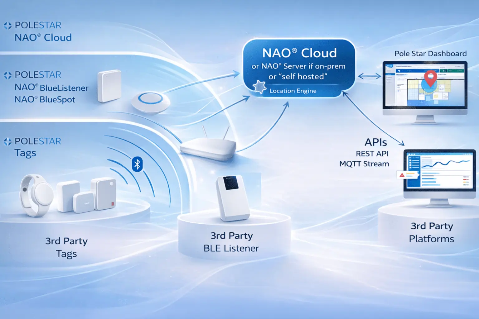
In a world where accuracy and continuity are essential, Pole Star offers the NAO Suite, an innovative solution that makes indoor location simple, reliable, and scalable. With a seamless transition between outdoor and indoor, NAO provides a seamless experience for the end user.
Based on Bluetooth Low Energy, a universal and economical technology, and enriched by the fusion of multiple contextual data thanks to advanced algorithms resulting from several years of R&D and continuous innovation, now amplified by AI, the NAO Suite guarantees exceptional performance: accuracy, availability, low latency, scalability, and reliability.
NAO Bluelistener
NAO® BlueListener is a BLE gateway that captures Bluetooth signals from tags, beacons and devices, sending them to NAO® Cloud or Server for processing by NAO® Track. It forms the sensing layer of the RTLS architecture, enabling precise and scalable indoor positioning. It supports standard BLE formats, integrates natively with the NAO® Suite, offers centralized supervision, encrypted communications and OTA updates, and is built for reliable 24/7 operation in complex environments.
NAO Mobile SDK
NAO® Mobile SDK provides precise, continuous indoor positioning for mobile apps by fusing BLE, Wi‑Fi, GNSS, LTE and motion sensors to compute real‑time 3D location. It works in complex indoor/outdoor environments, integrates with NAO® Cloud or Server, and is compatible with existing Wi‑Fi/BLE infrastructures. The SDK supports navigation, geofencing, operational tracking and large‑scale deployments while ensuring security, privacy and on‑device processing.
NAO Cloud
NAO® Cloud is the central platform of the NAO® Suite, managing and supervising large‑scale indoor location services. It centralizes BLE/Wi‑Fi data collection, standardizes real‑time location flows, and distributes them to components like NAO® Track, Mobile, Viewer and Flow. Through APIs and MQTT, it integrates with enterprise systems, offers centralized configuration and visualization, ensures security and GDPR compliance, and supports scalable, multi‑site deployments across cloud, on‑premise or hybrid models.
NAO Track
NAO® Track is the real‑time location engine of the NAO® Suite, transforming BLE signals into precise and reliable indoor positioning data while integrating seamlessly with existing BLE‑enabled infrastructures. Scalable and secure, it can run in the cloud or on‑premise to meet governance requirements and supports large‑scale deployments across complex environments. It provides continuous visibility on movements, enables flow analysis, and strengthens safety through geofenced alerts and rapid incident response.
NAO Maps
NAO® Maps is the indoor mapping layer of the NAO® Suite, providing a structured, shared cartographic foundation for all positioning, tracking and geofencing services. It imports and structures maps by floor, enriches them with zones and infrastructure elements, and synchronizes updates in real time across NAO® Track, Viewer and Flow. Compatible with APIs and SDKs, it supports multi‑site deployments, secure hosting and integration into broader digital ecosystems.
NAO Viewer
NAO® Viewer is the real‑time supervision interface of the NAO® Suite, displaying live indoor positions of people, assets and equipment on maps from NAO® Maps. It centralizes visualization, alerts, dashboards and zone monitoring to give teams immediate situational awareness across multi‑floor and multi‑site environments. Integrated with NAO® Track, NAO® Flow and NAO® Cloud/Server, it supports decision‑making, incident response and operational coordination through secure, role‑based access.
NAO Server
NAO® Server is the self‑hosted version of NAO® Cloud, giving organizations full control over infrastructure, data governance and system operations. It is designed for sensitive or regulated environments requiring local data sovereignty. The platform offers advanced maintenance tools such as enhanced logging, service restarts and version rollback, and is delivered as a container‑based installation package. A clear version policy ensures stability, security and compatibility across the evolving NAO® Suite.
NAO Counting
NAO® Counting is an optional feature of the NAO® Suite that provides real‑time counting of tracked objects—BLE tags or smartphones—within predefined zones. It offers instant visibility on occupancy levels across areas without additional infrastructure. Counting data is delivered through secure MQTT APIs, displayed in NAO® Viewer, and accessible via the NAO® JS SDK. Activated on demand, it integrates natively with the platform, ensuring consistent, reliable and easy‑to‑deploy occupancy insights.
NAO Flow
NAO® Flow is a web application that analyzes and supervises the movement of BLE‑tracked people or assets across a site. It reconstructs journeys, highlights bottlenecks and detects anomalies such as long dwell times or route deviations, generating alerts when needed. The tool links tags to equipment or staff, visualizes movements on maps through its built‑in NAO® Viewer, and offers customizable dashboards. It can be deployed in SaaS or self‑hosted environments and integrates securely via MQTT.