
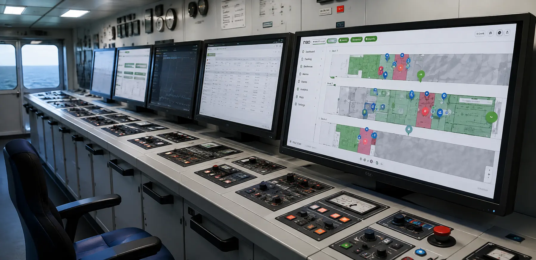
Cruise ships are among the most complex environments to manage from a safety perspective. With multiple decks, thousands of passengers and crew members, public spaces, cabins, technical areas and constantly changing operational conditions, maintaining effective cruise ship safety requires more than traditional procedures alone.
A Real-Time Location System (RTLS) provides cruise operators with continuous visibility into the location of people and assets across a vessel. By combining indoor positioning, Bluetooth Low Energy (BLE), location software, geofencing and real-time dashboards, RTLS can support passenger tracking, crew safety, emergency mustering, asset visibility and emergency response.
The objective is not simply to know where someone is. It is to transform real-time location data into actionable safety information across the vessel.
What is RTLS for cruise ships?
A Real-Time Location System (RTLS) is a technology that continuously determines the location of people and assets in environments where traditional GPS or GNSS positioning is unavailable or unreliable.
On a cruise ship, an RTLS can use technologies such as Bluetooth Low Energy (BLE), Wi-Fi and other positioning technologies. Tags, badges, smartphones or other devices transmit signals that are captured by onboard infrastructure. A software location engine then processes those signals and converts them into a real-time position.
Pole Star’s RTLS Explained guide describes how an RTLS uses tags, smartphones, BLE infrastructure and a location engine to generate real-time positioning information.
The resulting location data can be displayed on digital maps and connected to operational systems, allowing cruise operators to:
- Track passengers and crew members
- Locate children in designated areas
- Monitor emergency teams
- Support emergency mustering
- Monitor hazardous and restricted zones
- Track critical assets and equipment
- Trigger location-based alerts
- Analyse movement and operational activity
For cruise operators, RTLS therefore becomes more than a tracking technology. It can act as a location intelligence layer connecting safety, emergency response and daily operations.
Why is cruise ship safety a location problem?
A cruise ship is effectively a floating, multi-level city.
Passengers and crew members can be distributed across numerous decks, cabins, restaurants, entertainment areas, children’s zones, technical compartments and outdoor spaces.
During normal operations, this creates a complex environment to manage. During an emergency, knowing the location of people becomes even more important.
The fundamental challenge is simple:
Knowing that an incident has happened is not enough. Operators also need to understand where people are and how the situation is evolving.
This can be particularly important when emergency teams need to locate a crew member, identify personnel remaining in a hazardous area or verify that a zone has been evacuated.
International maritime safety requirements under SOLAS include provisions relating to muster stations, emergency training and drills, muster lists and emergency instructions. The International Maritime Organization’s SOLAS Chapter III requirements provide the official regulatory framework.
RTLS does not replace these procedures or the decisions of trained crew members. Instead, it can provide an additional layer of real-time location intelligence to support established cruise ship safety procedures.
How does RTLS improve cruise ship safety?
RTLS connects several elements that can otherwise be difficult to combine in real time:
People → location → zones → events → alerts → action
A crew member wearing a location-enabled badge can be positioned on a digital map. If that person enters a restricted area, triggers an emergency alert or remains inside a hazardous zone during an evacuation, the location information can become part of an operational workflow.
This makes location data actionable rather than simply visual.
Key RTLS applications for cruise ship safety
| RTLS capability | Cruise ship safety application | Operational value |
|---|---|---|
| Passenger tracking | Locate passengers across multiple decks | Better situational awareness |
| Child tracking | Locate children in designated areas | Additional child safety visibility |
| Crew tracking | Locate crew and emergency teams | Faster coordination |
| Emergency mustering | Monitor personnel during evacuation | Better accountability |
| Geofencing | Monitor hazardous and restricted areas | Location-based alerts |
| Asset tracking | Locate emergency and operational equipment | Faster access to resources |
| Location intelligence | Analyse movements and events | Better operational decisions |
This ability to support multiple workflows from the same location layer is one of the main advantages of RTLS.
Passenger tracking and child safety on cruise ships
One of the most important applications of indoor positioning is passenger tracking.
Large cruise ships can accommodate thousands of passengers across multiple decks and activity areas. In normal operations, real-time location can support passenger services and navigation. During an incident, the same infrastructure can provide additional situational awareness.
Depending on the deployment, passengers can be located through smartphones, wearable devices or dedicated tags.
Potential applications include:
- Locating passengers requesting assistance
- Supporting passengers requiring additional assistance
- Locating children within designated activity areas
- Helping authorised staff identify a passenger’s location
- Supporting emergency response
- Understanding passenger movement through different areas
Pole Star’s cruise ship RTLS solutions address passenger and crew location, child safety, emergency response and other maritime use cases.
How does child tracking work on a cruise ship?
A child can wear a BLE-enabled wristband or another location-enabled device. The device periodically transmits a signal that is received by the vessel’s positioning infrastructure.
The location engine processes those signals and determines the child’s position, which can then be displayed on an indoor map.
The same location data can also be combined with geofencing, allowing specific areas of the vessel to be defined as digital zones.
This means that passenger tracking and child safety can use the same underlying indoor positioning infrastructure as other cruise ship safety applications.
Crew safety and emergency team tracking
Crew members are central to cruise ship safety. They operate throughout the vessel, including public areas, cabins, technical compartments and engine rooms.
During an emergency, knowing the location of crew members can help safety teams understand where personnel are and coordinate their response.
A real-time crew tracking system can provide:
- Live crew location
- Emergency team visibility
- Location-aware alerts
- Visibility across multiple decks
- Better coordination during incidents
For example, when a crew member activates an emergency alert from a location-enabled badge, the safety team can receive both the alert and information about where the person is located.
The emergency question therefore changes from:
“Who needs help?”
to:
“Who needs help, and where are they?”
Pole Star’s worker safety and real-time location solution uses BLE badges and phones to associate emergency alerts with the person’s identity and location.
Emergency mustering and evacuation verification
Emergency mustering is one of the most important applications of RTLS for cruise ship safety.
During an emergency, cruise operators need to account for passengers and crew and ensure that established evacuation and muster procedures are followed.
SOLAS Chapter III includes specific requirements concerning passenger ships, including muster stations, emergency training and drills, and muster lists and emergency instructions. The IMO’s official SOLAS Chapter III summary provides further details.
RTLS can complement these procedures by providing real-time information about personnel locations.
How does RTLS support emergency mustering?
A typical workflow can involve:
- Crew members carry location-enabled badges.
- The RTLS continuously determines their positions.
- Muster stations and safety zones are digitally defined.
- An emergency event activates the relevant workflow.
- Safety teams can view personnel on a digital map.
- Evacuation progress can be monitored.
- The system can maintain a digital record of the event.
The IMO also states that newly embarked passengers on relevant voyages must undergo safety drills including mustering at lifeboat stations before the ship departs or immediately upon departure. The IMO’s passenger drill requirements provide the official background.
RTLS does not replace the muster process. Instead, it can provide an additional digital layer of visibility during and after the process.
CO₂ mustering in cruise ship engine rooms
CO₂-protected areas are one of the most safety-critical applications for real-time location technology.
CO₂ fire suppression systems are designed to extinguish fires rapidly, but the presence of personnel inside a protected area creates a serious safety risk.
SOLAS Chapter II-2 covers fire protection, fire detection and fire extinction and includes requirements relating to fire safety, evacuation, emergency training and drills. The IMO’s SOLAS Chapter II-2 summary provides the official framework.
A digital CO₂ mustering system can determine which personnel are inside a protected zone and monitor evacuation in real time.
Pole Star’s CO₂ mustering solution is designed around this type of use case, using real-time personnel location to support evacuation verification.
A real-world example is Pole Star’s Carnival Maritime case study. The deployment covers 11 ships and uses BLE badges on Cisco infrastructure for CO₂ mustering and crew safety.
The workflow can provide:
- Personnel counting by zone
- Real-time location of badge wearers
- Emergency alerts
- Evacuation monitoring
- Zone-clear confirmation
- Timestamped event records
Important: RTLS should be treated as a supporting safety and verification layer. It does not replace the vessel’s approved procedures, crew responsibilities or regulatory decision-making.
Geofencing and hazardous-zone monitoring
Another important RTLS application is indoor geofencing.
A geofence is a digitally defined zone on an indoor map. When a tracked person or asset enters, exits or remains within a predefined area, the system can trigger an alert or workflow.
On a cruise ship, geofences can represent:
- Engine rooms
- CO₂-protected areas
- Restricted technical compartments
- Crew-only zones
- Muster stations
- Emergency response areas
- Passenger zones
The logic is straightforward:
Person enters zone → location identified → rule triggered → authorised team alerted
This allows cruise operators to move from passive location tracking to active safety monitoring.
Pole Star’s indoor geofencing solution uses digitally defined zones to trigger alerts, logs or API events when tracked people or assets cross predefined boundaries.
Asset visibility and equipment tracking
Cruise ship safety is not only about tracking people.
Vessels also depend on mobile equipment and operational assets, including:
- Medical equipment
- Emergency equipment
- Maintenance tools
- Cleaning equipment
- Service carts
- Other operational resources
When equipment is difficult to locate, crew members can lose valuable time searching for it.
An RTLS can provide a real-time view of where tagged assets are located.
Why is asset tracking important for cruise ship safety?
| Challenge | Traditional approach | RTLS-enabled approach |
|---|---|---|
| Emergency equipment | Search manually | View current location |
| Medical equipment | Availability difficult to confirm | Check location in real time |
| Maintenance equipment | Time spent searching | Locate equipment quickly |
| Mobile assets | Limited visibility | Live location and movement |
| Restricted equipment | Manual monitoring | Zone-based monitoring |
This creates an important secondary benefit: the same infrastructure deployed for cruise ship safety can also improve operational efficiency.
Bluetooth SIG identifies asset tracking and people tracking among the applications of Bluetooth-based RTLS and indoor location services. Its Bluetooth Location Services overview explains how Bluetooth technology can support indoor positioning and real-time locating systems.
Real-time location intelligence across complex vessels
Tracking is only the first layer of an RTLS.
Once location data is collected continuously, operators can use it to generate broader real-time location intelligence.
Instead of simply asking:
Where is this person?
operators can start asking:
- How are people moving through the vessel?
- Where are bottlenecks occurring?
- Which areas are most active?
- Where are assets being used?
- How quickly did an emergency team reach an incident?
- Which areas experience recurring operational issues?
This transforms location data into operational information.
Location data → context → intelligence → action
Pole Star’s Indoor Positioning System guide explains how indoor positioning provides real-time visibility into people, assets and processes in environments where traditional GPS positioning is not sufficient.
How does indoor positioning work on a cruise ship?
A cruise ship RTLS typically combines four main components:
- Tags, badges, wristbands or smartphones
- BLE or other wireless infrastructure
- A positioning engine
- Software applications and dashboards
Step 1: A device emits a signal
A BLE badge, wristband, asset tag or smartphone emits a wireless signal.
Step 2: Onboard infrastructure receives the signal
BLE-enabled access points or other receivers capture signals from different locations across the vessel.
Step 3: The location engine calculates the position
The location engine processes the signals and calculates the device’s position.
Modern RTLS software can use techniques such as fingerprinting, filtering and calibration to transform wireless signals into a more stable location.
Pole Star explains this architecture in its RTLS Explained guide, including the role of BLE infrastructure, tags and smartphones, the location engine and the software platform.
Bluetooth SIG similarly describes Bluetooth as a positioning technology capable of supporting indoor location services and RTLS applications for people and assets.
Step 4: Location becomes operational data
The resulting location can be displayed through:
- Digital maps
- Dashboards
- Mobile applications
- Alerts
- APIs
- Operational systems
The same location layer can therefore support passenger tracking, crew safety, emergency mustering, geofencing and asset tracking.
Which positioning technology is best for cruise ship RTLS?
There is no single positioning technology that is optimal for every cruise ship safety use case.
The choice depends on factors such as:
- Required accuracy
- Deployment scale
- Existing infrastructure
- Battery requirements
- Smartphone compatibility
- Cost
- Operational environment
| Criteria | BLE | UWB | Wi-Fi | RFID |
|---|---|---|---|---|
| Accuracy | High | Very high | Medium | Low to medium |
| Cost | Low | High | Medium | Low to medium |
| Scalability | Excellent | Good | Excellent | Good |
| Smartphone compatibility | Excellent | Limited | Excellent | Limited |
| Real-time tracking | Excellent | Excellent | Good | Limited |
| Battery efficiency | Excellent | Good | Low to medium | Excellent |
| Typical cruise applications | Passenger tracking, crew safety, mustering and geofencing | High-precision tracking | Connectivity and location applications | Asset identification |
Bluetooth SIG notes that Bluetooth technology is widely used for indoor positioning and that Bluetooth-based RTLS can support the tracking of both people and assets.
For large-scale people and asset tracking, BLE can therefore be attractive because of its scalability and low-power characteristics.
UWB can be appropriate where a use case genuinely requires very high positioning precision.
The key question is therefore not simply:
“BLE or UWB?”
but:
“What level of location accuracy does this cruise ship safety use case actually require?”
Bluetooth also supports dedicated positioning capabilities through Direction Finding. Its official documentation describes Angle of Arrival and Angle of Departure as Bluetooth positioning mechanisms. Learn more about Bluetooth Direction Finding.
Why does on-premise RTLS matter for cruise ships?
Cruise ships operate in a different connectivity environment from most land-based facilities.
A safety-critical system cannot necessarily assume continuous access to the public internet, cloud services or shore-based infrastructure.
This makes on-premise RTLS architecture an important consideration for maritime applications.
An onboard RTLS can process location information locally, supporting:
- Low-latency location processing
- Operational independence
- Local data processing
- Greater resilience
- Reduced dependency on external connectivity
Pole Star’s Carnival Maritime deployment is described as fully on-premise and operates across the fleet’s existing Cisco BLE infrastructure.
For safety-critical workflows such as CO₂ mustering, this architecture can be particularly relevant because location processing does not have to depend on an external cloud connection.
RTLS vs traditional cruise ship safety procedures
RTLS should not be considered a replacement for established cruise ship safety procedures.
Instead, it provides an additional digital layer of visibility.
| Traditional approach | RTLS-enabled approach |
|---|---|
| Manual headcounts | Real-time location-based visibility |
| Radio-based location confirmation | Live position on a digital map |
| Periodic checks | Continuous location updates |
| Manual zone verification | Digital geofencing |
| Search for equipment | Real-time asset location |
| Information distributed across teams | Centralised operational visibility |
| Limited post-event visibility | Location data available for analysis |
The greatest value comes from combining technology with established maritime safety procedures, trained personnel and regulatory requirements.
What should cruise operators look for in an RTLS?
Choosing a cruise ship RTLS should start with the operational problem rather than the technology itself.
1. Accuracy
Different safety applications require different levels of accuracy.
A muster application may require reliable room- or zone-level visibility, while another application may require more precise positioning.
The objective should be to achieve the accuracy required by the operational use case rather than automatically choosing the most precise technology available.
2. Scalability
The platform should support large numbers of passengers, crew members and assets across multiple decks and potentially multiple vessels.
3. Onboard reliability
Safety-critical workflows should not unnecessarily depend on external connectivity.
4. Existing infrastructure
Using existing BLE-capable wireless infrastructure can simplify deployment and reduce the need for a separate sensor network.
5. Battery life
Passenger wristbands, crew badges and asset tags need to operate reliably over long periods.
6. Open integrations
The RTLS should be capable of connecting location data to applications and operational systems through APIs and other integration mechanisms.
7. Privacy and security
Passenger and crew location data should be managed according to applicable privacy, security and operational requirements.
8. Multiple use cases
A strong RTLS platform should allow cruise operators to build several applications on the same location layer.
This means the same infrastructure can potentially support passenger tracking, crew safety, emergency mustering, geofencing and asset tracking rather than requiring separate positioning systems for every application.
One location layer can support multiple cruise ship safety workflows
The biggest strategic advantage of RTLS is that the same location infrastructure can support multiple applications.
Passenger tracking
Locate passengers across multiple decks.
Crew safety
Locate crew members and emergency teams.
Emergency mustering
Monitor personnel presence and evacuation.
Geofencing
Monitor restricted and hazardous zones.
Asset tracking
Locate critical equipment.
Location intelligence
Analyse movements and operational performance.
This creates a common real-time location layer across the vessel.
Instead of deploying disconnected technologies for every individual problem, cruise operators can build multiple workflows around the same positioning infrastructure.
Cruise ship safety: from tracking to real-time location intelligence
The evolution of cruise ship safety technology is moving beyond simple tracking.
The opportunity is to connect:
People + assets + zones + alerts + operational systems
through a shared real-time location layer.
An RTLS can help cruise operators answer three increasingly important questions:
Where is everyone?
What is happening?
What should happen next?
For passenger safety, this can mean locating children or passengers requiring assistance.
For crew safety, it can mean locating emergency teams and personnel in high-risk areas.
For emergency mustering, it can mean gaining additional real-time visibility into evacuation progress.
For operations, it can mean knowing where critical assets are and how people and equipment move throughout the vessel.
For safety management, it can mean turning real-time location data into actionable intelligence.
As cruise ships become larger and more operationally complex, real-time location technology can provide the visibility needed to support safer, more responsive and more connected vessels.
Frequently asked questions about cruise ship safety and RTLS
What is cruise ship safety?
Cruise ship safety encompasses the systems, procedures, technologies and trained personnel used to protect passengers, crew members and vessels during normal operations and emergencies. It includes emergency preparedness, mustering, evacuation procedures, fire safety, crew training and incident response.
What is RTLS on a cruise ship?
RTLS, or Real-Time Location System, is a technology used to determine the real-time location of people and assets across a cruise ship. It can use technologies such as BLE, Wi-Fi and UWB to support passenger tracking, crew safety, emergency mustering, geofencing and asset tracking.
How does RTLS improve cruise ship safety?
RTLS provides real-time information about where passengers, crew members and assets are located. This can support emergency response, personnel accountability, mustering, restricted-zone monitoring and faster access to critical resources.
Can RTLS track passengers on a cruise ship?
Yes. Depending on the system and use case, passengers can be located using smartphones, wearable devices or other location-enabled technologies. Passenger tracking can support child safety, assistance requests, navigation and emergency response.
Can cruise ships track children in real time?
Yes. Location-enabled wristbands or other wearable devices can allow authorised parents or staff to see a child’s location across designated areas of a vessel. Geofencing can also be used to monitor movement between predefined zones.
How does RTLS support crew safety?
RTLS can provide real-time visibility of crew members and emergency response teams. This can help safety officers coordinate teams across multiple decks and locate personnel during incidents.
What is emergency mustering on a cruise ship?
Emergency mustering is the process of assembling and accounting for passengers or crew members at designated muster stations or safety areas during an emergency. RTLS can complement established procedures by providing additional real-time visibility into personnel locations.
What is CO₂ mustering?
CO₂ mustering is the safety-critical process of verifying that personnel have evacuated a CO₂-protected area before the fire suppression system is activated. Real-time indoor positioning can help identify personnel remaining inside a protected zone and monitor evacuation progress.
Does RTLS replace cruise ship emergency procedures?
No. RTLS should support, not replace, approved emergency procedures, trained personnel and regulatory requirements. Its role is to provide an additional layer of real-time location visibility and operational information.
Does RTLS require an internet connection on a cruise ship?
Not necessarily. RTLS architectures can be designed to process location data locally onboard the vessel. This can reduce dependence on internet or satellite connectivity for safety-critical workflows.
Which technology is best for cruise ship RTLS?
The answer depends on the use case. BLE is well suited to large-scale people and asset tracking, while UWB can be appropriate for applications requiring very high positioning precision. Wi-Fi and RFID can also have roles depending on operational requirements.
How accurate is indoor positioning on a cruise ship?
Accuracy depends on the positioning technology, infrastructure, vessel environment and software algorithms. Many RTLS applications do not require centimetre-level accuracy. Room- or zone-level positioning can be sufficient for applications such as mustering and geofencing.
What assets can be tracked on a cruise ship?
RTLS can track a wide range of mobile assets, including maintenance equipment, medical equipment, cleaning carts, emergency equipment and other operational resources.
Why is real-time location intelligence important for cruise operators?
Real-time location intelligence turns positioning data into operational information. It can help cruise operators understand where people and assets are, monitor zones, coordinate emergency response, analyse movement and improve operational decision-making.
Conclusion
Cruise ship safety increasingly depends on situational awareness.
When thousands of passengers and crew members move across a complex, multi-deck environment, knowing where people and critical assets are can provide an additional layer of information for emergency response and daily operations.
RTLS provides the location layer that connects passenger tracking, crew safety, emergency mustering, geofencing, asset visibility and real-time location intelligence.
By combining indoor positioning with operational software, digital maps and location-based workflows, cruise operators can move from simply knowing that an incident has occurred to understanding where people are, what is happening and how teams can respond.
For cruise operators looking to explore real-time location technology, discover Pole Star’s cruise ship RTLS solutions.